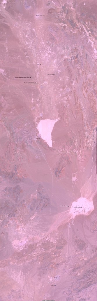
The above image is my followup to my Nevada Test Site Tour post from last month and comes courtesy of Adam Schneider’s very useful GPS Visualizer (you really need to see it full-sized{#15521015&size=o}, though). I still don’t have a cable to connect the ancient Magellan GPS I used to a computer, so I manually entered the waypoints I marked into the form and selected a few options, and viola.
Here are the points so you can have your own fun (the image above doesn’t include ‘A’):
name,desc,latitude,longitude
A,Atomic Testing Museum,36.114444444444445,-115.14916666666667
B,Main Gate,36.645833333333336,-116.00194444444445
C,Mess Hall,36.66083333333333,-115.99722222222222
D,HazMat Spill Test Facility,36.801944444444445,-115.96944444444445
E,Railroad Bridge Test,36.79944444444444,-115.93666666666667
F,Control Point,36.93444444444444,-116.05111111111111
G,Bilby Crater (208KT),37.06027777777778,-116.0225
H,Ice Cap,37.08083333333334,-116.04555555555555
I,Sedan Crater (100KT),37.177499999999995,-116.04833333333333
J,Aircraft Anti-terrorism Ground Training Site,37.055,-116.10166666666666
K,House Damaged By Effects Test,37.04555555555555,-116.07833333333333
L,House Damaged By Effects Test,37.04222222222222,-116.07
Click on the links to go to Google’s high-res images for each area.
Related: Vegas Guide Part Three: Nukes and Moon Hoaxes and Chernobyl Tour.